Land Settlement is the process through which Records of Rights are prepared. It is a very extensive exercise which takes several years to complete. Several experienced revenue officials conduct this operation and is led by Settlement Officer. During settlement operations, powers of the Collector, except revenue collection, are transferred to Settlement Officer which ordinarily vest in the Deputy Commissioner. The Revenue & Estate Department Khyber Pakhtunkhwa has undertaken Settlement Operations in various units of the Province. The traditional manual Settlements have not only proved time consuming but with the passage of time the requisite expertise has also gone extinct.
Keeping these factors in view therefore, Revenue & Estate Department Khyber Pakhtunkhwa has taken a courageous and correct decision of shifting to technology-based Settlements. This could prove to be very revolutionary step in constructing digitized records and ultimately contributing to the concept of digital world to fulfil the modern-day requirements.Therefore, The GIS based Settlement in Dir Lower, Dir Upper, Kalam Tehsil (Swat) is a vital step in that direction. This GIS Based Settlement along with another GIS Based Settlement launched by the Revenue & Estate Department Khyber Pakhtunkhwa in the newly merged Districts are the first of its kind in the country. Some of the advantages of this GIS Based Settlement are its speed, accuracy, transparency, construction of digitized records and giving live services to public immediately after construction of record of rights.
The main objectives of this Project are
- Complete Settlement Operation using GIS Based Technology.
- Provision of Computerized Transactional Services to the Land Owners.
- Initiation of GIS based land settlement operation.
- Survey entire project area using advanced surveying equipment i.e. embedded with RTK and GNSS technology
- Data entry of records of rights and all other related data in the existing LRMIS software.
- Creation of digital Massavi Maps
- Creation of spatial database to store all GIS related data.
- Integration of MIS and GIS data in the existing LRMIS software.
- Provide scalable database solution to accommodate land transaction data both in spatial and non-spatial formats.
- To maintain and update the existing digital records and prepare digitized Jamabandis from the computerized records.
- To mitigate land disputes by auto update of the Land Records.
- To prepare scalable digital maps for multi sector and multipurpose uses.
- To classify the land and determine digital Girdawari of the Project Area.
- To increase revenue for the Fard and Mutation services
- To reduce litigation by accurately maintaining the digital records of rights.
- To facilitate land owners and farmers for acquisition of bank loans.
- Provision of land related services to other relevant departments such P&D, Agriculture, C&W and Sports etc.
- To provide online services to public to locate their land.
Following are some of the important documents created during this process of Settlement.
- Shajra Nasab (Pedigree/Family Tree)
- Khatoni (Records of Tenancy)
- Field Book (Measurement dimensions)
- Massavi (Cadastral Map)
- Misl e Haqiat (Record of Rights)
- Wajib ul Arz (Document of Customs) of mauza/village
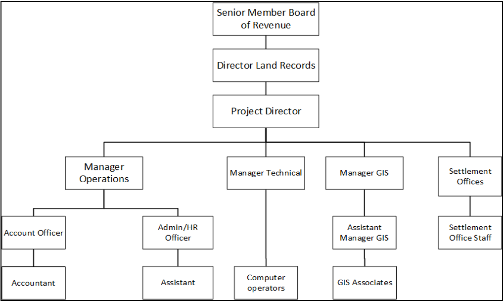
The project is headed by Project Director. Project Director is answerable to Secretary Revenue & Estate Department through Director Land Records. The Project Director is assisted by three managers and three Settlement Officers. Complete hierarchy of the project is given in the organogram
Land Records Management Information System (LRMIS) has already been in use in Service Delivery Centers (SDCs) of District Peshawar, Mardan and Abbotabad etc. The in house developed software of Land Settlement Module will be integrated with current LRMIS software. Initial data entry of Shajra e Nasab and Khatoni will be stored in Settlement Module. After the necessary verification (Partal) the data will be updated in LRMIS database.
Khasra measurement and Field Book preparation will be done using GIS technology as illustrated in Figure below. All the Khasra measurement will be done using Very High Resolution Satellite Stereo Imagery and using advanced surveying equipment i.e. DGPS + GNSS. This data will be stored in a Geo-database and then after verification from concerned revenue staff, will be integrated with LRMIS database. After completing all the required processes of Settlement Operation, the data will be ready for live services.